From the blog
Currently displaying: All
Cache-Breaking for Faster Web Application Updates (4 min)
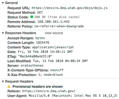
When Production Is Broken, It Needs to Be Fixed Now!Recently, the URL changed for one of the map services we use in several of our applications. This came as a bit of a surprise to us, so we quickly u
SGID Data Lifecycle (2 min)
Over the past several months, UGRC has been updating the State Geographic Information Database (SGID) data lifecycle process. The data lifecycle process starts with data creation and extends to finali
Transitioning to a New World, ArcPro (5 min)
I have spent the last 4 months learning and using ArcPro while also learning a new job (see the end of this post). Like many of my fellow GIS users, I was hesitant to make the leap into the unknown af
Dumbing Down Terrain with Contour Polygons (4 min)
While technology advances towards products with greater resolution and accuracy, sometimes more data isn’t always better data. Sometimes, being able to see general trends and relative differences pain
The Evolution of a Python Script (7 min)
Python is a very approachable programming language and scripting in python is quick and powerful - Create a file, type some code, and a repeatable script is produced. Python is installed on most compu
Utah Recognized in NSGIC Geospatial Excellence Awards (2 min)
Through its Geospatial Excellence Awards, the National States Geographic Information Council (NSGIC) recognizes individuals and organizations that advance the capabilities of geospatial technology, an
UGRC System Status Page (2 min)
Over the years, GIS is trending more and more towards being web-based. UGRC has tried to keep step with this trend with the addition of the discover, the Turn GPS RTK GPS service, and the Web API hand
Rethinking Geocoders: Adding Local Vernacular into the Build Process (5 min)
UGRC has been working on a project to enhance our approach to geocoding. This grew from the basic idea that humans often view addressing differently than a GIS system. For instance, as GIS professiona
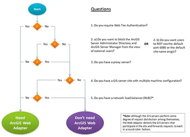
Removing and Replacing the Esri Web Adaptor (3 min)
The Esri web adaptor is a small load balancer/reverse proxy bundled into the ArcGIS Server install but do you know if you need it?ArcGIS Server runs an http server exposed over the private port 6080.