From the blog
Currently displaying: All
Thoughts from Teaching Google and Amazon New Skills (9 min)
Developing software for digital assistants is fun and a refreshing change from typical GIS projects. Over the past few months, UGRC was lucky enough to spend some time developing equivalent skills for
GIS Wisdom - Exploring the Reverse Approach (7 min)
Those of us working in GIS know that it's really powerful and that it's utilized in just about every industry. If you aren’t yet a true believer, you should check out this impressive list of uses.GIS
The Western Grid, Explained (10 min)
Have you ever wondered why the patterns of development in the Western United States are so orthogonal (i.e., "right-angled")?Fig 1: 1891 Salt Lake City Bird's Eye View[^1]Pan around a map and you'll s
Creating New State Plane Zone for 2022 (2 min)
In 2022 the plans to publish a series of new horizontal reference frames that will replace the and a vertical reference frame that will replace the .The new horizontal reference frames are the:The n
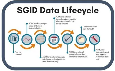
The SGID, Moving Forward (3 min)
In an effort to ultimately consolidate and organize as much State GIS data as possible, UGRC has been gathering information about SGID data layers managed by UGRC, and we are now reaching out to state
Meet Nathan Kota - New UGRC Staff (6 min)
UGRC would like to welcome Nathan Kota, the new Information Technology Manager. Nathan is going to help build and manage the development team as well as take our project management skills to the next
The Incredible Shrinking SGID (3 min)
Over the past several months, UGRC has been reviewing the usage of the State Geographic Information Database (SGID) data layers in order to determine how to most effectively be a steward of the state’
Leveraging Git and GitHub to Manage the Lifecycle of Custom ArcGIS Tools (13 min)
As GIS developers, we are often expected to provide the same custom tool for multiple versions of ArcGIS Desktop (or ArcGIS Pro). For example, some users are on Desktop 10.4, while others are on 10.6
Don't Make Users Think about Updating Software (6 min)
As software developers, we want the people who are using our software to ~~enjoy~~ the experience. Developers strive to create a positive user experience to increase the popularity and usage of their