Quick Links
- 2006 Wasatch Front, Iron County, Heber Valley
- 2011 Great Salt Lake, Cedar Valley, Hurricane Fault
- 2013-2014 Wasatch Front and the Wasatch Fault
- 2015 Zion National Park
- 2015 Colorado, Green & Yampa Rivers
- 2016 FORGE
- 2016 Monroe Mountain
- 2016 Great Salt Lake & Utah Lake
- 2016 Bear Lake, Bear River, Cache Valley & Upper Weber Valley
- 2016 Kanab Utah
- 2017 Washington County
- 2017 Washakie and Whites Valley
- 2017 Millsite Reservoir
- 2018 Sanpete Valley
- 2018 Southern Utah
- 2018 Central Utah
- 2018 Northern Utah
- 2018 Box Elder County
- 2018 Uintah Basin and Heber Valley
- 2019 Strawberry River
- 2019 Kane County
- 2020 Southern Utah
- 2020 Northern & Central Utah
- 2020 Central & Southern Utah
- 2020 Logan River Watershed
- 2020 FEMA HQ
- 2022 Fish Springs (topo-bathy)
- 2022 Western & Eastern Utah
- 2023 U.S. Forest Service
- 2025 Moab Utah
Light Detection and Ranging (Lidar) is an optical remote sensing technology that can measure the distance to, or other properties of, a target by illuminating the target with light often using pulses from a laser. Currently this is the most accurate elevation dataset UGRC has and bare-earth DEMs/DTMs and first-return DSMs are available for most of Utah.
UGRC has partnered with various agencies over the years to acquire many Lidar datasets with the goal of statewide coverage. Visit Raster.utah.gov , opens in a new tab to explore and download all collections of Lidar derived bare-earth DEMs/DTMs and first-return DSMs elevation models. The Utah Lidar Coverage , opens in a new tab application is also available to explore all Lidar projects that have been proposed, are in progress, or completed in Utah. Both applications can get you to a project specific webpage for more information about each project including reports, metadata, and vector data associated with each project.
With a few exceptions projects have a UTM NAD83(2011) zone 12 north meters NAVD88 projection however the geoid model can vary. For more information refer to the project specific reports and metadata.
The naming convention for the tile downloads are based off the U.S. National Grid (USNG) , opens in a new tab .
In addition to the bare-earth DEMs/DTMs and first-return DSMs, the LAS point clouds are available from The National Map , opens in a new tab managed by the USGS. The National Map downloader also facilitates bulk downloads.
For more information about Lidar visit Exploring Lidar.
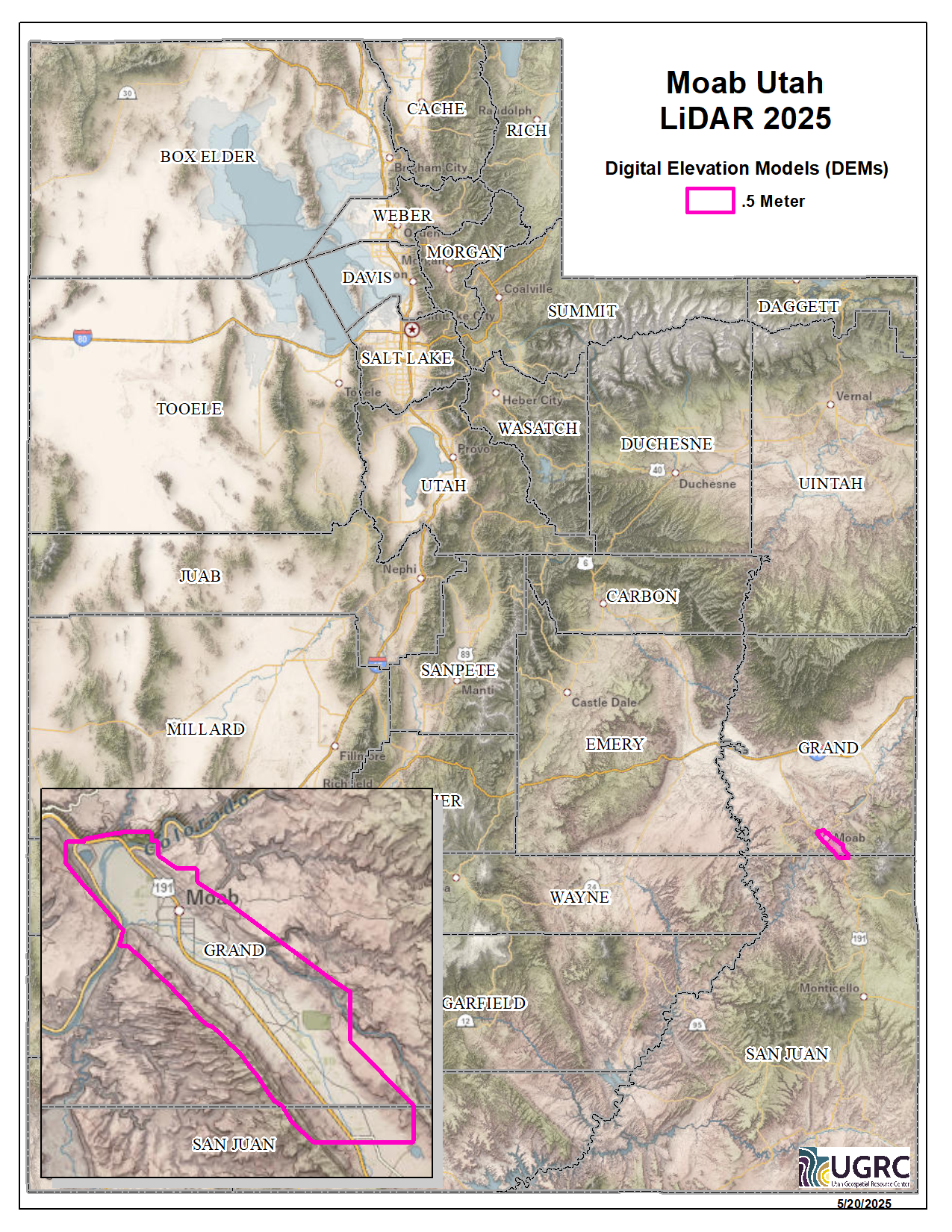
2025 Moab Utah
During 2025 Grand County, UT acquired ~31 square miles of 8 points per meter Quality Level 1 Lidar of Moab City. The 0.5 resolution bare earth DEMs and first-return/highest-hit DSMs in .tif format have a 10.0cm vertical RMSE accuracy and are available for download. This elevation data was collected March 23rd, 2025.
Project assets
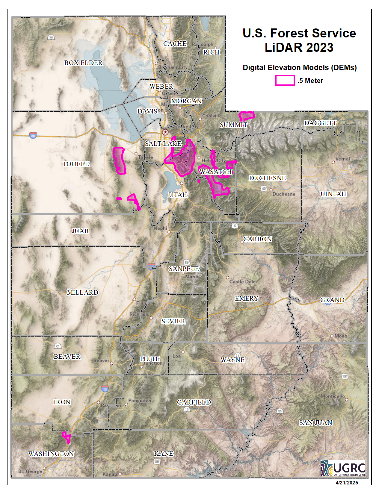
2023 U.S. Forest Service
During 2023 the U.S. Forest Service (USFS) acquired ~778 square miles of 8 points per meter Quality Level 1 Lidar for portions of Utah. The 0.5 resolution bare earth DEMs and first-return/highest-hit DSMs in .tif format have a 10.0cm vertical RMSE accuracy and are available for download. The LAS point clouds are available from The National Map , opens in a new tab . This elevation data was collected between June and October, 2022. Please note this dataset is in the Albers projection (NAD 1983 (2011) Contiguous USA Albers).
Project assets
2022 Western & Eastern Utah
During 2022 UGRC, the Utah Division of Emergency Management, the Natural Resource Conservation Service (NRCS), the U.S. Forest Service (USFS), and the Federal Emergency Management Agency (FEMA) acquired ~19,466 square miles of 2 and 8 points per meter Quality Level 1 & 2 Lidar for portions of Western and Eastern Utah. The 0.5 and 1 meter resolution bare earth DEMs and first-return/highest-hit DSMs in .tif format have a 10.0cm vertical RMSE accuracy and are available for download. The LAS point clouds are available from The National Map , opens in a new tab . This elevation data was collected between June and October, 2022.
Project assets

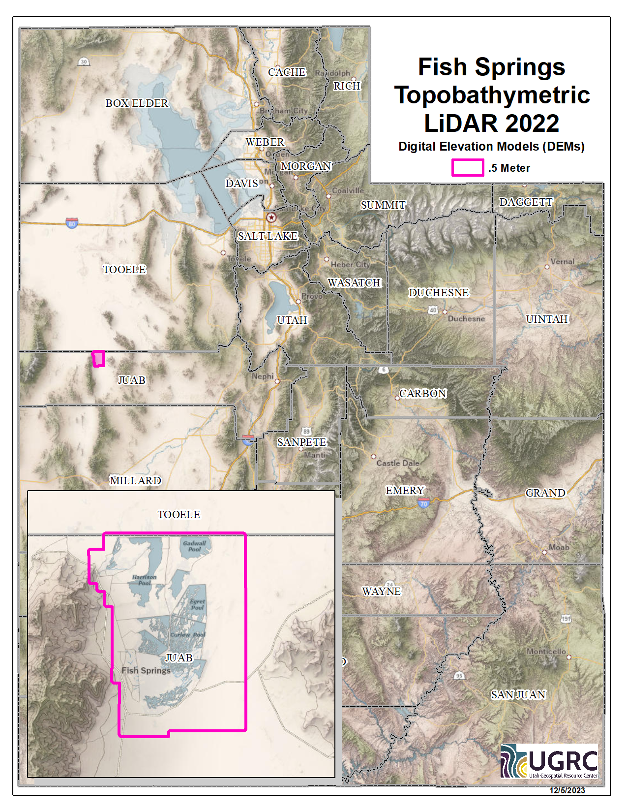
2022 Fish Springs (topo-bathy)
In 2022 the U.S. Geological Survey (USGS) acquired 29.5 square miles of 8 points per meter Quality Level 1 Topobathymetric Lidar of Fish Springs National Wildlife Refuge in Utah. The 0.5 resolution topo-bathy DEMs in .tif format have a 10.0cm vertical RMSE accuracy and are available for download. The LAS point clouds are available from The National Map , opens in a new tab . This elevation data was collected September 24, 2022.
Project assets
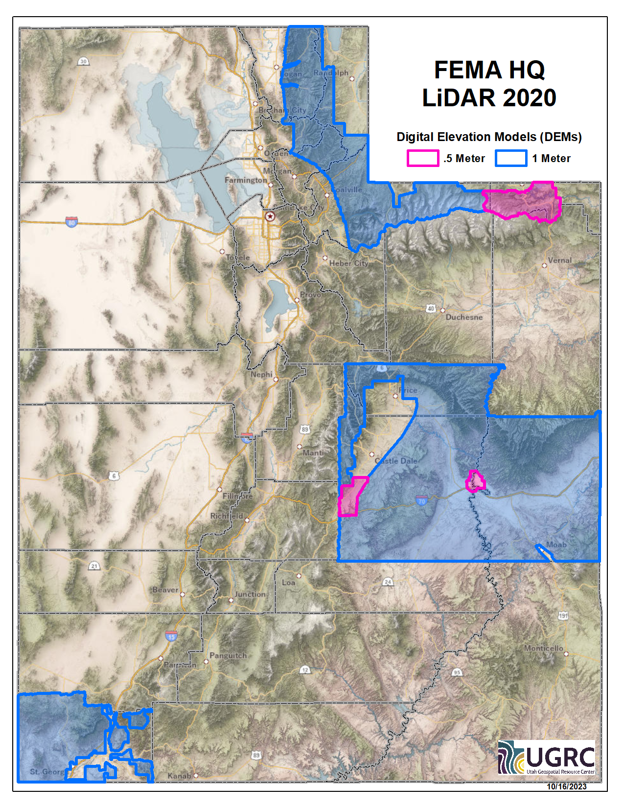
2020 FEMA HQ
During 2020 UGRC, the Utah Division of Emergency Management, the Natural Resource Conservation Service (NRCS), the U.S. Forest Service (USFS), and the Federal Emergency Management Agency (FEMA) acquired ~13,686 square miles of 2 and 8 points per meter Quality Level 1 & 2 Lidar for portions of Utah. The 0.5 and 1 meter resolution bare earth DEMs in .tif format have a 10.0cm vertical RMSE accuracy and are available for download. The LAS point clouds are available from The National Map , opens in a new tab . This elevation data was collected between August and November, 2020.
Project assets
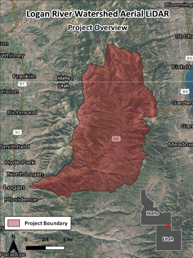
2020 Logan River Watershed
During 2020 Utah State University, Utah Water Research Laboratory acquired ~216 square miles of 8 points per meter Lidar of the Logan River Watershed in Northern Utah. The 0.5 meter resolution bare earth DEMs and first-return/highest-hit DSMs in .tif format have been tested to a 0.106 ft vertical RMSE accuracy and are available for download. This elevation data was collected August 12-13, 2020.
This elevation data has a State Plane Utah North NAD83(CORS96) NAVD88 projection with units in US Feet.
Project assets
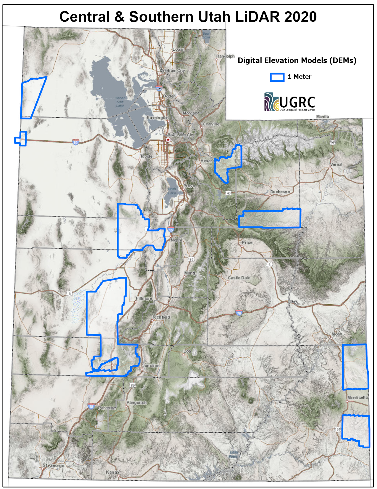
2020 Central & Southern Utah
During 2020 UGRC, the Natural Resource Conservation Service (NRCS), and the Utah Division of Emergency Management acquired ~5,143 square miles of 2 points per meter Quality Level 2 Lidar for portions of Central and Southern Utah. The 1 meter resolution bare earth DEMs and first-return/highest-hit DSMs in .tif format have a 10.0cm vertical RMSE accuracy and are available for download. The LAS point clouds are available from The National Map , opens in a new tab . This elevation data was collected between September and October, 2020.
Project assets
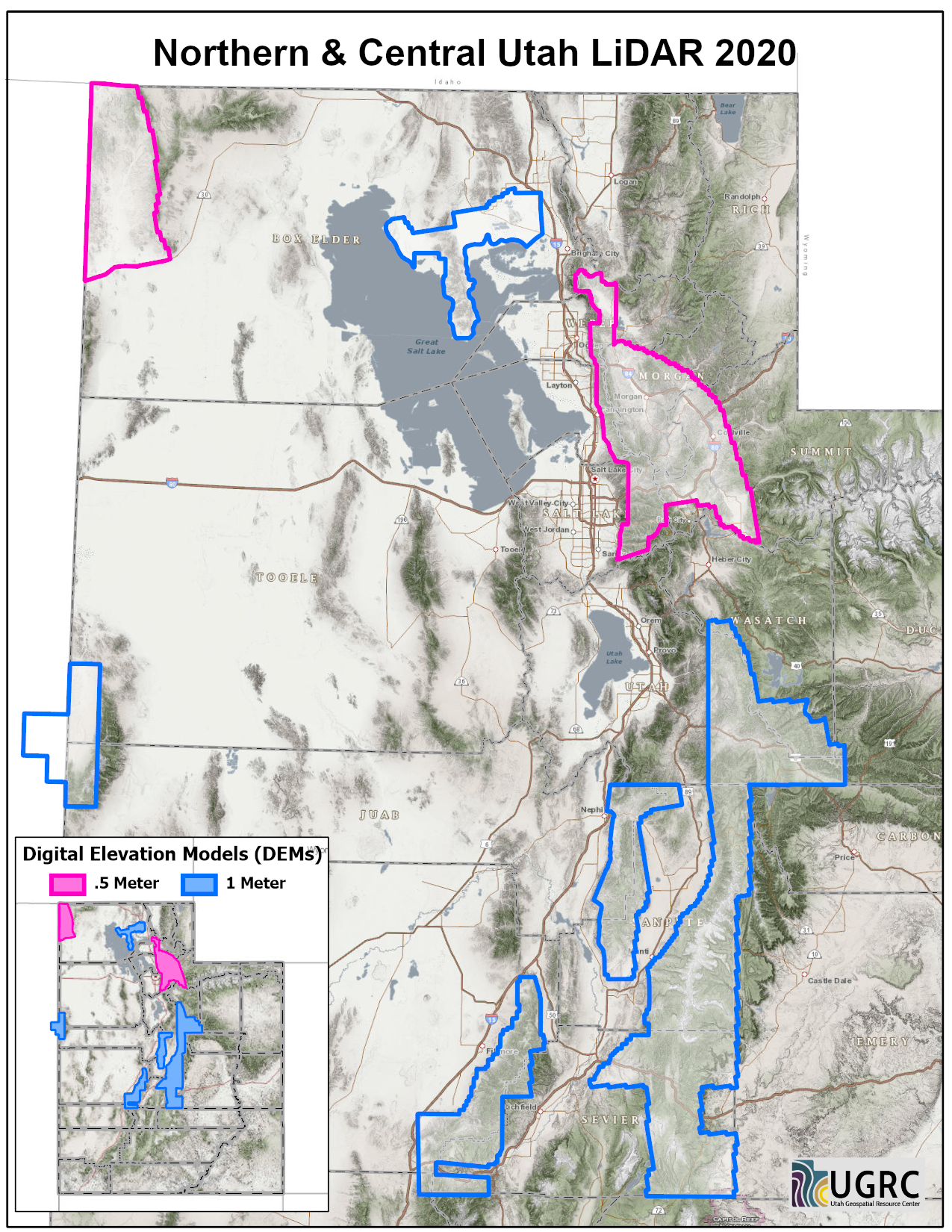
2020 Northern & Central Utah
During 2020 UGRC, the Natural Resource Conservation Service (NRCS), and the Utah Division of Emergency Management acquired ~5,262 square miles of 2 and 8 points per meter Quality Level 1 & 2 Lidar for portions of Northern and Central Utah. The 0.5 and 1 meter resolution bare earth DEMs and first-return/highest-hit DSMs in .tif format have a 10.0cm vertical RMSE accuracy and are available for download. The LAS point clouds are available from The National Map , opens in a new tab . This elevation data was collected between April and July, 2020.
This elevation data has a UTM NAD83 (2011) zone 12 north meters NAVD88(GEOID12) projection with the exception of a small strip on the western edge of the project area in zone 11.
Project assets
2020 Southern Utah
During 2020 UGRC and the Utah Division of Emergency Management acquired ~9,740 square miles of 2 and 8 points per meter Quality Level 1 & 2 Lidar for portions of Southern Utah. The 0.5 and 1 meter resolution bare earth DEMs and first-return/highest-hit DSMs in .tif format have a 10.0cm vertical RMSE accuracy and are available for download. The LAS point clouds are available from The National Map , opens in a new tab . This elevation data was collected between May and July, 2020.
Project assets

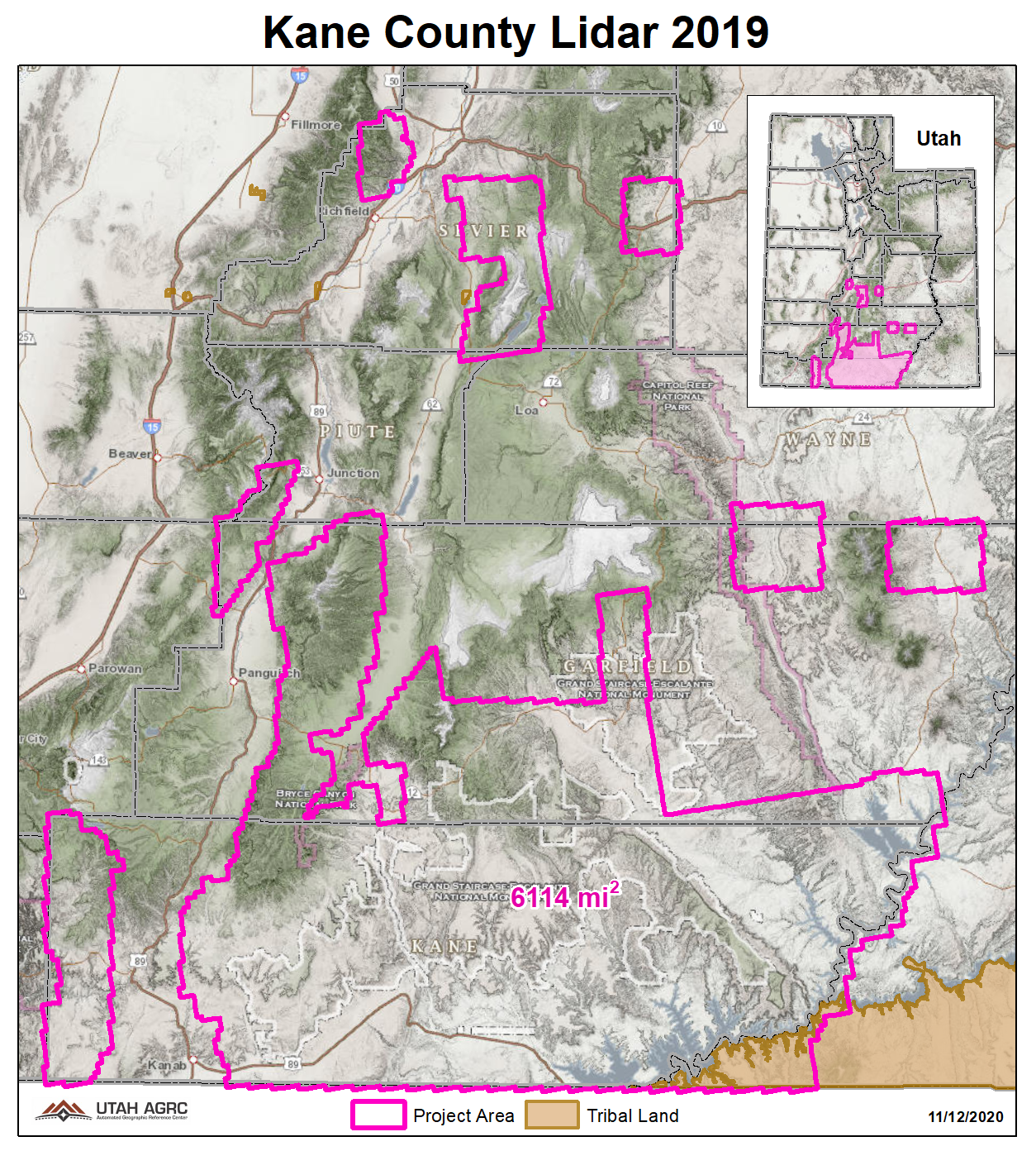
2019 Kane County
During 2019 UGRC and the Utah Division of Emergency Management acquired ~6,114 square miles of 2 points per meter Quality Level 2 Lidar of Kane County and portions of the Greater Sevier Watershed. The 1 meter resolution bare earth DEMs and first-return/highest-hit DSMs in .tif format have a 10.0cm vertical RMSE accuracy and are available for download. The LAS point clouds are available from The National Map , opens in a new tab .
Project assets
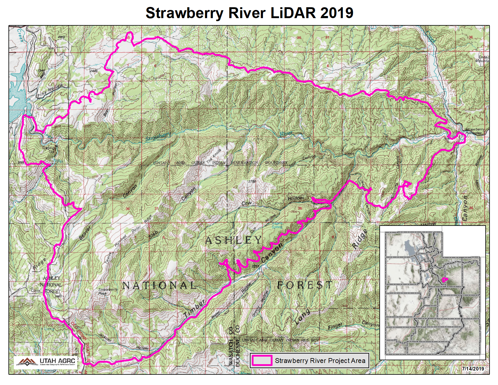
2019 Strawberry River
During 2019 UGRC and the Utah Reclamation Mitigation Conservation Commission (URMCC) acquired ~92 square miles of 8 points per meter Quality Level 1 Lidar and 10cm 4-band aerial photography of the Strawberry River, from Soldier Creek Dam to The Pinnacles, after the Dollar Ridge Fire in 2018. The 0.5 meter resolution bare earth DEMs and first-return/highest-hit DSMs in .tif format have a 10.0cm vertical RMSE accuracy and are available for download. The LAS point clouds are available from The National Map , opens in a new tab . This elevation data was collected August 15-18, 2019.
Project assets
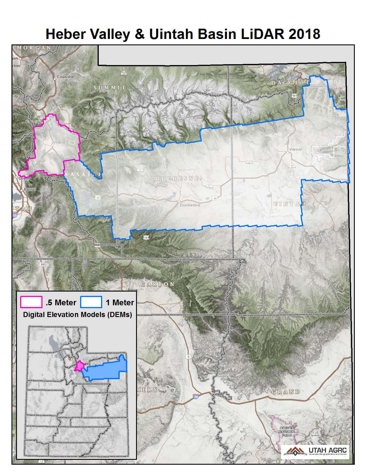
2018 Uintah Basin and Heber Valley
During 2018 the Federal Emergency Management Agency (FEMA) acquired ~4,693 square miles of 2 and 8 points per meter Quality Level 1 & 2 Lidar for areas in Northern Utah that include the Uintah Basin (QL2) and Heber Valley (QL1). The 0.5 and 1 meter resolution bare earth DEMs in .img format have a 10.0cm vertical RMSE accuracy and are available for download. The LAS point clouds are available from The National Map , opens in a new tab . This elevation data was collected between June and October, 2018.
Project assets
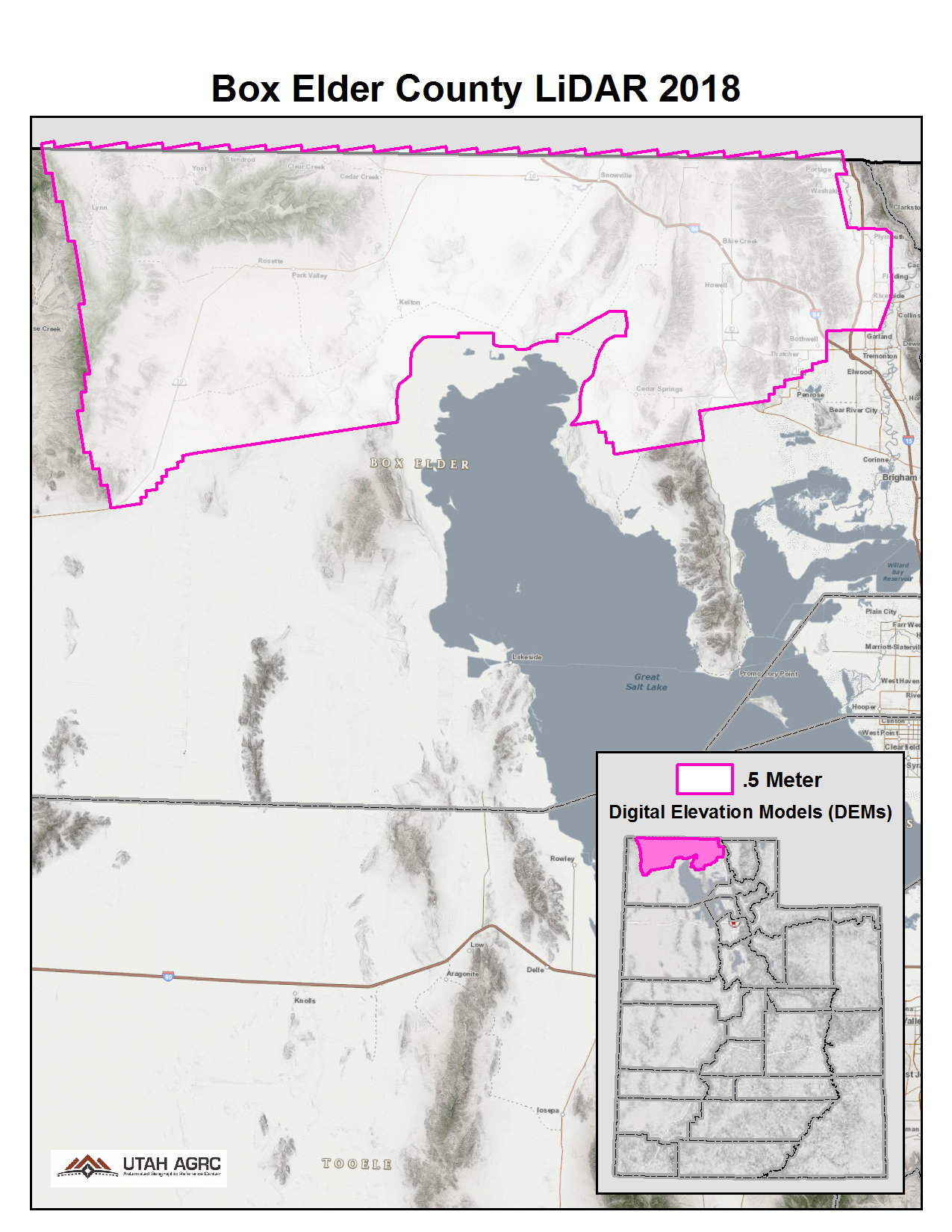
2018 Box Elder County
During 2018 UGRC, the Natural Resource Conservation Service (NRCS), and the Utah Geological Survey (UGS) acquired ~2,271 square miles of 8 points per meter Quality Level 1 Lidar for areas in Northern Utah. The 0.5 meter resolution bare earth DEMs and first-return/highest-hit DSMs in .tif format have a 10.0cm vertical RMSE accuracy and are available for download. The LAS point clouds are available from The National Map , opens in a new tab .
Project assets
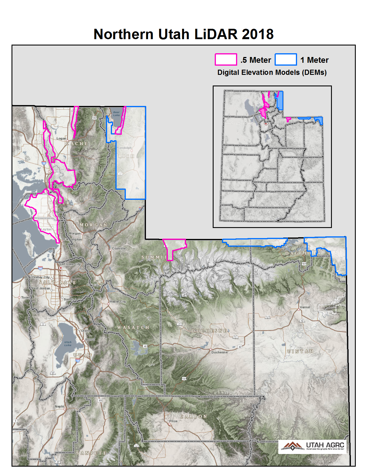
2018 Northern Utah
During 2018 UGRC, the Natural Resource Conservation Service (NRCS), and the Utah Geological Survey (UGS) acquired ~1,632 square miles of 2 and 8 points per meter Quality Level 1 & 2 Lidar for areas in Northern Utah. The 0.5 and 1 meter resolution bare earth DEMs and first-return/highest-hit DSMs in .tif format have a 10.0cm vertical RMSE accuracy and are available for download. The LAS point clouds are available from The National Map , opens in a new tab .
Project assets
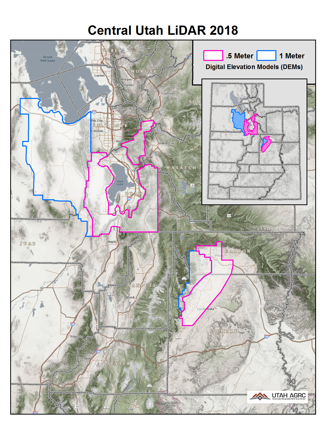
2018 Central Utah
During 2018 UGRC, the Utah Division of Emergency Management, the Natural Resource Conservation Service (NRCS), and the Utah Geological Survey (UGS) acquired ~3,759 square miles of 2 and 8 points per meter Quality Level 1 & 2 Lidar for areas in Central Utah. The 0.5 and 1 meter resolution bare earth DEMs and first-return/highest-hit DSMs in .tif format have a 10.0cm vertical RMSE accuracy and are available for download. The LAS point clouds are available from The National Map , opens in a new tab .
Project assets
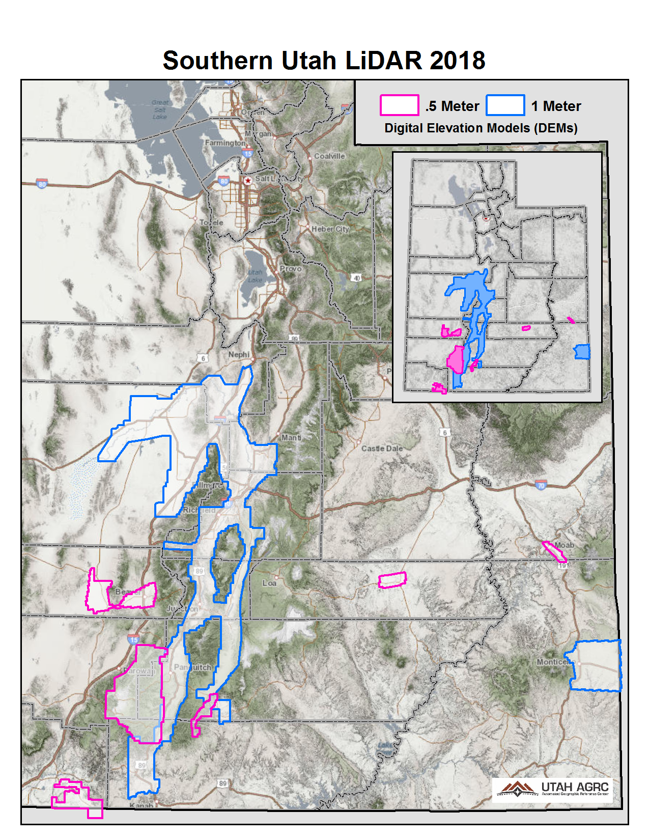
2018 Southern Utah
During 2018 UGRC, Utah Division of Emergency Management, US National Park Service, and US Forest Service acquired ~5,466 square miles of 2 and 8 points per meter Quality Level 1 & 2 Lidar for areas in Southern Utah. The 0.5 and 1 meter resolution bare earth DEMs and first-return/highest-hit DSMs in .tif format have a 10.0cm vertical RMSE accuracy and are available for download. The LAS point clouds are available from The National Map , opens in a new tab .
Project assets
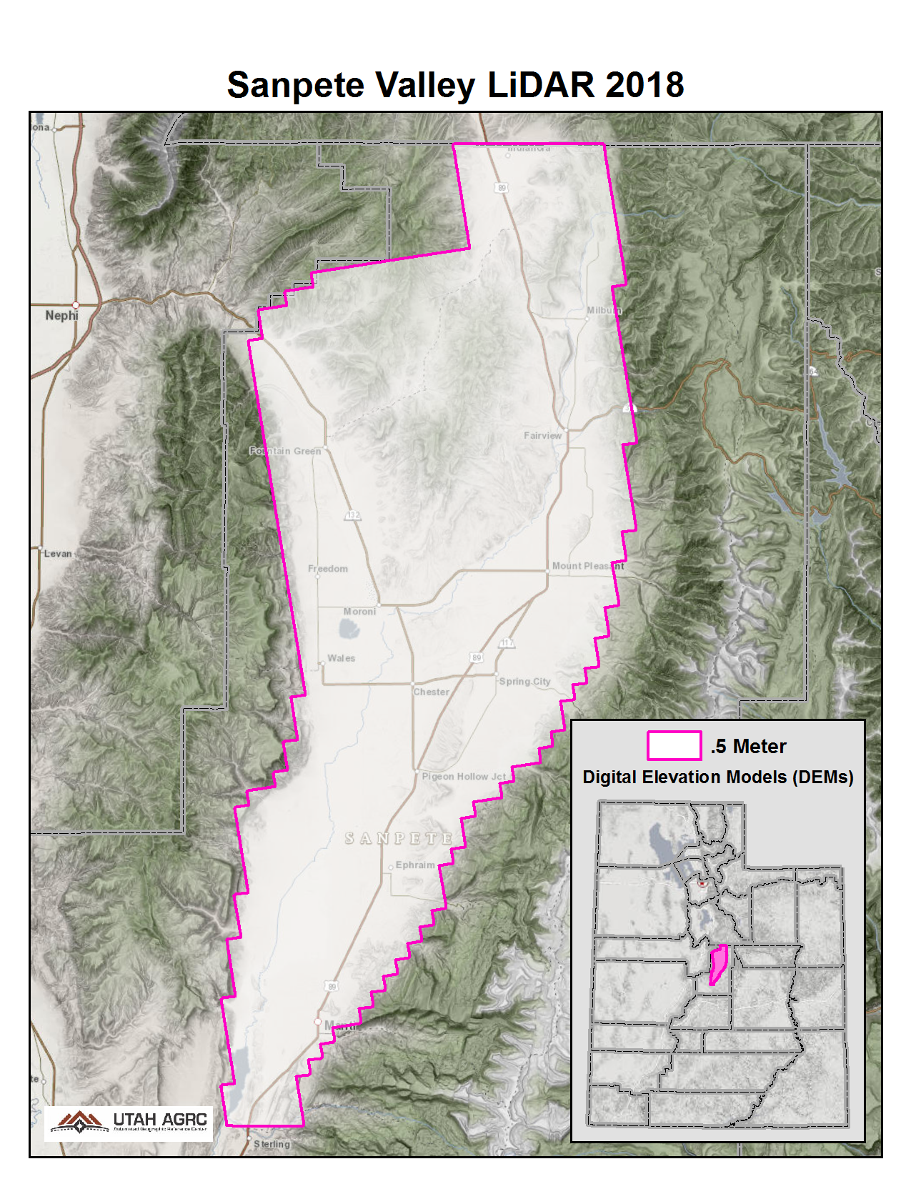
2018 Sanpete Valley
During 2018 UGRC, the Natural Resource Conservation Service (NRCS), and the Utah Geological Survey (UGS) acquired ~440 square miles of 8 points per meter Quality Level 1 Lidar in Central Utah. The 0.5 meter resolution bare earth DEMs and first-return/highest-hit DSMs in .img format have a 10.0cm vertical RMSE accuracy and are available for download. The LAS point clouds are available from The National Map , opens in a new tab .
Project assets
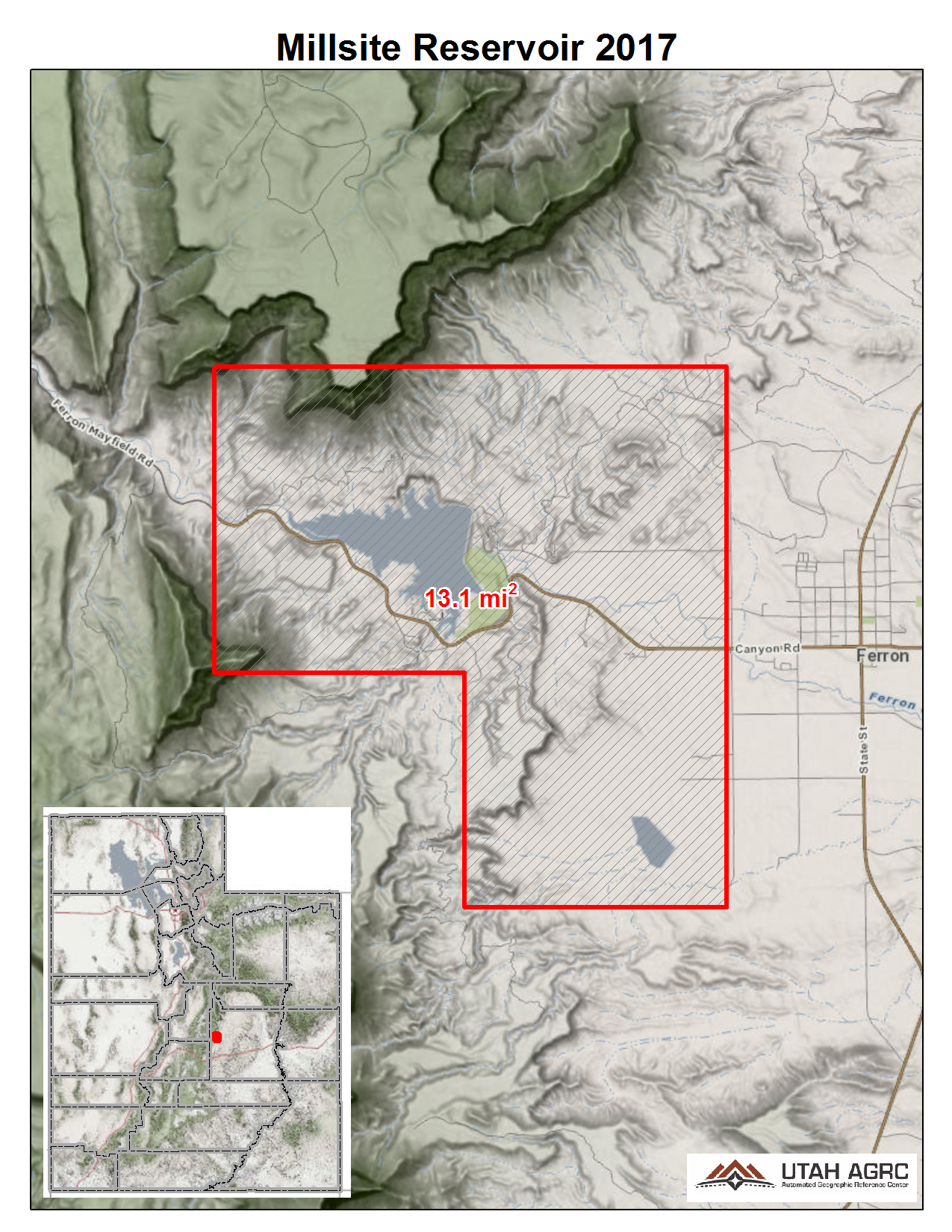
2017 Millsite Reservoir
During the Fall of 2017 UGRC and the U.S. Department of Agriculture, Natural Resources Conservation Service acquired ~13 square miles of 8 points per meter Quality Level 1 Lidar of Millsite Reservoir, Utah. The 0.5 meter resolution bare earth DEMs and first-return/highest-hit DSMs in .img format have a 10.0cm vertical RMSE accuracy and are available for download. The LAS point clouds are available from The National Map , opens in a new tab . This elevation data was collected October 21 and 25, 2017 when the reservoir was drained.
Project assets
2017 Washakie and Whites Valley
During the Spring of 2017 UGRC and the Utah Department of Natural Resources, Division of Water Resources acquired ~28 square miles of 8 points per meter Quality Level 1 Lidar of Washakie, Utah and Whites Valley in Northern Utah. The 0.5 meter resolution bare earth DEMs and first-return/highest-hit DSMs in .img format have a 10.0cm vertical RMSE accuracy and are available for download. The LAS point clouds are available from The National Map , opens in a new tab . This elevation data was collected April 15-16, 2017.
Project assets

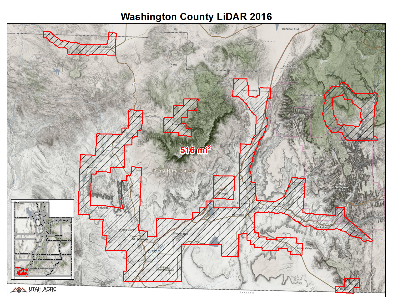
2017 Washington County
During the Spring of 2017 UGRC, Washington County, and the Utah Division of Emergency Management acquired ~516 square miles of 2 points per meter Quality Level 2 Lidar of areas within Washington County in Southwestern Utah. The 1 meter resolution bare earth DEMs and first-return/highest-hit DSMs in .img format have a 10.0cm vertical RMSE accuracy and are available for download. The LAS point clouds are available from The National Map , opens in a new tab .
Project assets
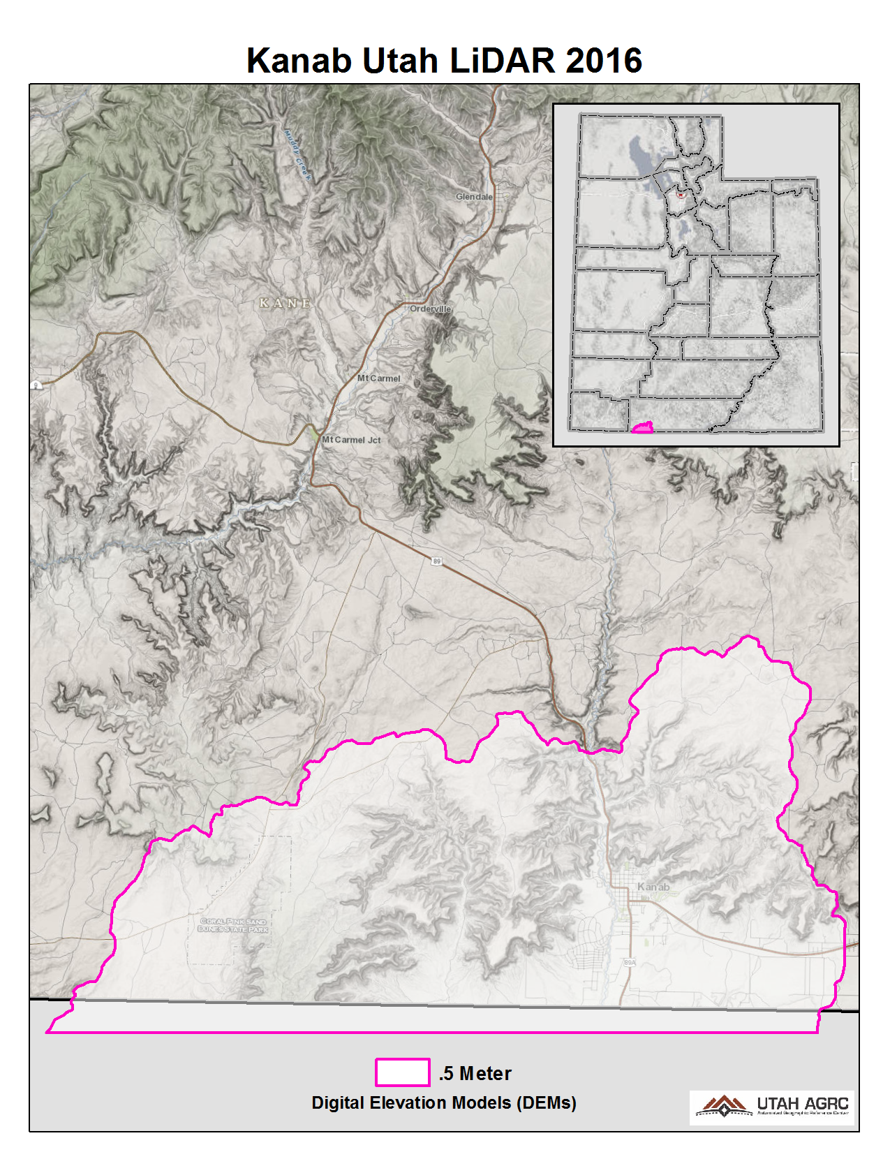
2016 Kanab Utah
In 2016 the Natural Resource Conservation Service (NRCS) acquired Lidar around Fredonia, AZ that covers ~150 square miles of Utah with 8 points per meter Quality Level 1 Lidar and includes Kanab, UT. The 0.5 meter resolution bare earth DEMs and first-return/highest-hit DSMs in .img format have a 10.0cm vertical RMSE accuracy and are available for download. The LAS point clouds, classified to ground, low, medium, are available from The National Map , opens in a new tab . This elevation data was collected between October and December, 2016.
Project assets
2016 Bear Lake, Bear River, Cache Valley & Upper Weber Valley
During the Fall of 2016 UGRC, Cache and Weber County, and the Utah Department of Emergency Management acquired ~790 square miles of 8 points per meter Quality Level 1 Lidar. The project areas cover the Cache Valley, Upper Weber Valley, Bear River from Cache County to the Great Salt Lake, and the Bear Lake shoreline. The 0.5 meter resolution bare earth DEMs and first-return/highest-hit DSMs in .img format have a 10.0cm vertical RMSE accuracy and are available for download. The LAS point clouds are available from The National Map , opens in a new tab . This elevation data was collected between September, 2016 and November, 2017.
Project assets

2016 Great Salt Lake & Utah Lake
During the Fall of 2016 UGRC, Utah Geological Survey, and the Utah Division of Forestry, Fire and State Lands acquired ~1,555 square miles of 2 and 8 ppm Quality Level 1 and 2 Lidar of the Great Salt Lake and Utah Lake. The GSL portion of the project, collected between September and November 2016, is a combination of 0.5 QL1 and 1 meter QL2. Some areas are available as 0.5 meter although the entire GSL project areas is available as 1 meter. During the acquisition the GSL was at a historical low. The Utah Lake portion, collected between October and November 2016, is all 0.5 meter and is mainly the lake shoreline. The 0.5 and 1 meter resolution bare earth DEMs and first-return/highest-hit DSMs in .img format have a 10.0cm vertical RMSE accuracy and are available for download. The LAS point clouds are available from The National Map , opens in a new tab .
Project assets
- Download GSL project reports , opens in a new tab
- Download GSL project metadata , opens in a new tab
- Download GSL shapefiles of project area, tile indices, and breaklines , opens in a new tab
- Download Utah Lake project reports , opens in a new tab
- Download Utah Lake project metadata , opens in a new tab
- Download Utah Lake shapefiles of project area, tile indices, and breaklines , opens in a new tab

2016 Monroe Mountain
During the Summer of 2016 UGRC and the U.S. Forest Service acquired 292 square miles of 8 points per meter Quality Level 1 Lidar on Monroe Mountain in central Utah. The acquisition took place with leaf-on conditions to model the forest canopy in addition to ground elevations. The 0.5 meter resolution bare earth DEMs and first-return/highest-hit DSMs in .tif format have a 10.0cm vertical RMSE accuracy and are available for download. The LAS point clouds are available from The National Map , opens in a new tab .
Project assets

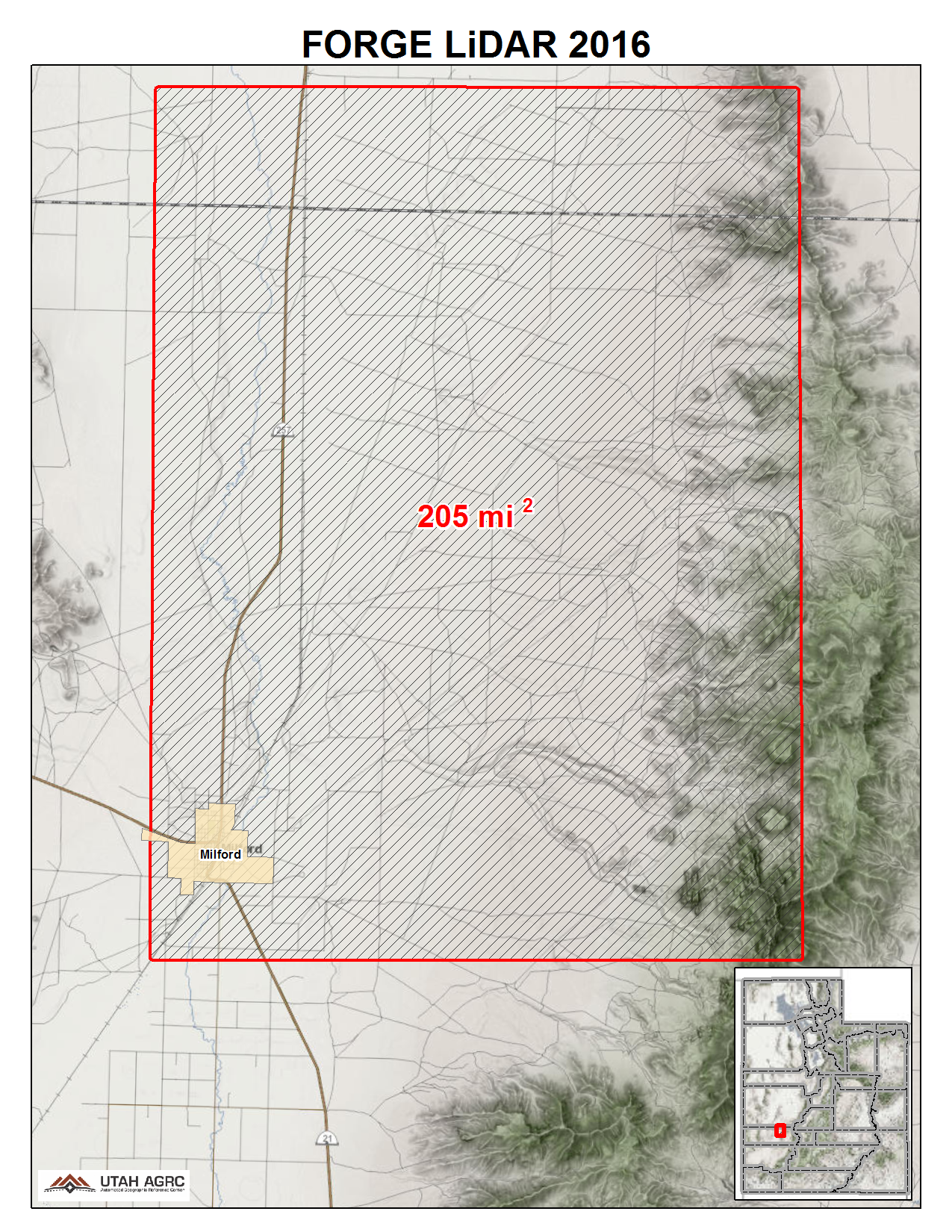
2016 FORGE
During the Fall of 2016 UGRC and the Utah Geological Survey acquired ~205 square miles of 8 points per meter Quality Level 1 Lidar of The Frontier Observatory for Research in Geothermal Energy (FORGE) area around Milford, Utah in Beaver and Millard Counties in western Utah. The 0.5 meter resolution bare earth DEMs and first-return/highest-hit DSMs in .img format have a 10.0cm vertical RMSE accuracy and are available for download. The LAS point clouds are available from The National Map , opens in a new tab . This elevation data was collected between October 26 and November 3, 2016.
Project assets
2015 Colorado, Green & Yampa Rivers
During late Fall of 2015 the Utah Division of Forestry, Fire & State Lands and the U.S. National Park Service acquired ~152 square miles covering ~680 river miles of 8 points per meter Lidar of the Colorado, Green, and Yampa rivers in Utah and Colorado. The Lidar collection is mainly of the river course and not the surrounding canyons. A small ~.8 square mile area was also collected in Arches N.P. The 0.5 meter resolution bare earth DEMs and first-return/highest-hit DSMs in .tif format have a 10.0cm vertical RMSE accuracy and are available for download. The LAS point clouds are available from The National Map , opens in a new tab . This elevation data was collected October and November of 2015 during low flow conditions.
Project assets

2015 Zion National Park
During 2015 and 2016 the U.S. Geological Survey and the U.S. Park Service acquired ~239 square miles of 2 and 8 points per meter Quality Level 1 & 2 Lidar for Zion National Park in Utah. The 0.5 and 1 meter resolution bare earth DEMs in .img format have a 10.0cm vertical RMSE accuracy and are available for download. The LAS point clouds, classified to ground, low, medium, and high vegetation, are available from The National Map , opens in a new tab . This elevation data was collected between November 2015 and July 2016
Project assets

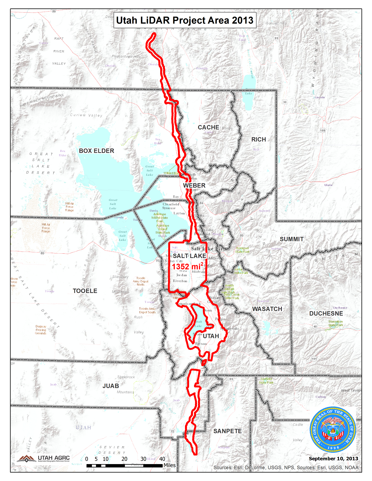
2013-2014 Wasatch Front and the Wasatch Fault
During the Fall of 2013 and the Spring of 2014 UGRC and partners acquired 1,422 square miles of 8 points per meter Quality Level 1 Lidar for areas along the Wasatch Front including the urbanized areas of Salt Lake County and Utah County and areas along the Wasatch Fault from Sanpete County north into Oneida County in southeast Idaho. The 0.5 meter resolution bare earth hydro flattened DTMs and first-return/highest-hit DSMs in .img format have a 9.25cm vertical RMSE accuracy. The LAS point clouds are available from The National Map , opens in a new tab .
Project assets
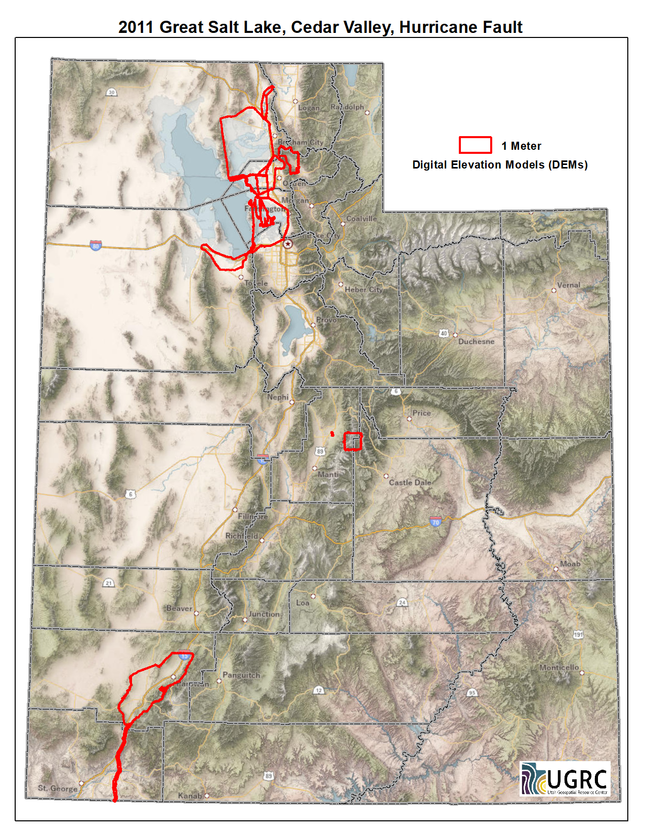
2011 Great Salt Lake, Cedar Valley, Hurricane Fault
During 2011 UGRC and Utah Geological Survey (UGS) acquired ~1,870 square miles of .85 meter Lidar for areas including the north, east, and south sides of the Great Salt Lake, Cedar Valley, Hurricane Fault, and more. The 1 meter bare-earth DEMs in .img format are available for download. The DSMs and LAS classified point clouds are available from Open Topography , opens in a new tab .
Project assets
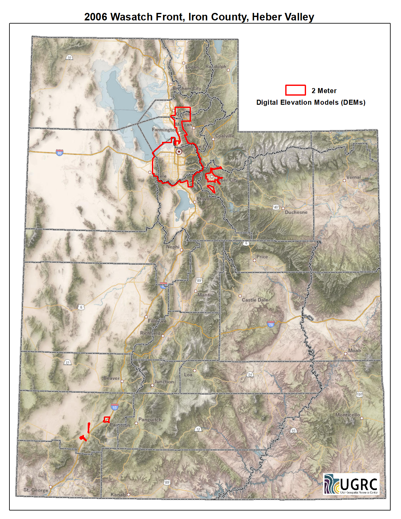
2006 Wasatch Front, Iron County, Heber Valley
During 2006 UGRC and partners acquired ~1,283 square miles of a combination of 1, 1.25, and 2 meter bare-earth DEMs derived from XYZi Lidar point clouds in .asc format. Acquisition areas include Salt Lake, Wasatch, and Iron counties.
Project assets