From the blog
Currently displaying: All
Utah SGID Statewide Roads Data Layer Updates (1 min)
UGRC recently completed updates to the SGID Roads data layer. Please visit our Roads and Highway System data page where you will find information about the Roads data model, as well as a web service l
Celebrating Ten Years of Discover (6 min)
We are celebrating 10 years of the Discover Basemap and Imagery Server this month! Discover is our one-stop shop for aerial imagery and custom Utah basemap services, all available from UGRC for free t
Utah SGID Statewide Roads Data Layer Updates (2 min)
Municipal Boundaries, Final update for 2024 (3 min)
To review any specific annexation document, visit the Utah Lt. Governor Municipal Certifications website.As always, feel free to check out all the changes and make sure your boundaries are where you t
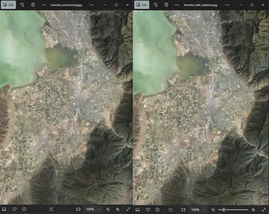
Getting Better Resolution from Raster Tile Imagery in Large Maps (5 min)
Have you ever added one of our WMTS Discover imagery layers to a map covering a large extent (a small-scale map) in ArcGIS Pro and tried to export it to a large PDF, only to have the imagery come out