Utah PLSS Point GCDB
Last update · December 15, 2020
The Public Land Survey System (PLSS) points for the State of Utah are based on Geographic Coordinate Data Base (GCDB) coordinate data. This data is Utah PLSS Fabric Version 2.3 2020 of the Utah GCDB.
Use the data
Explore and Download
Utah PLSS Point GCDB , opens in a new tab in the SGID on ArcGIS Utah PLSS Point GCDB feature service , opens in a new tabQuick clips
Feature service URL
https://services1.arcgis.com/99lidPhWCzftIe9K/ArcGIS/rest/services/UtahPLSSGCDBPoints/FeatureServer/0 Open SGID sample query
select * from cadastre.plss_point_gcdb limit 10; Getting started
Tip
A closer look
These are the corner points of the PLSS. This data set contains summary information about the coordinate location and reliability of corner coordinate information. The information in the corner feature has been collected by the identified data steward. For more information about corner locations, credits and use limitations the identified data steward in the corner feature should be contacted.
This data set represents the GIS version of the Public Land Survey System. Updates are expected annually as horizontal control positions from published sources and global positioning system (GPS) observations are added. The primary source for the data is cadastral survey records housed by the BLM supplemented with local records and geographic control coordinates from states, counties as well as other federal agencies such as the USGS and USFS. This data was originally published on 1/3/2017.
The PLSS serves as the backbone for all descriptions of private property and public land boundaries across Utah. Given their foundational role in legal property descriptions, it is imperative that these corner locations remain correct, precise, and readily available. By maintaining the accuracy of these corners and making their locations easily accessible, the potential for boundary discrepancies and disputes is significantly reduced, fostering greater clarity and confidence in land ownership and boundary delineation.
To facilitate this crucial task, the Utah Geospatial Resource Center (UGRC) has developed and maintained the PLSS web application , opens in a new tab since 2013, serving as a vital resource for surveyors across the state. Initially designed to provide access to PLSS monument record sheets, the app has since evolved to enable surveyors to upload their own monument record sheets. Continual improvements are made to meet the evolving needs of surveyors, ensuring that the app remains a comprehensive and user-friendly tool for accessing critical survey data. You can read more about the application in our application portfolio highlights.
Update history
- December 15, 2020
- October 15, 2019
- January 15, 2019
- January 1, 2018
- November 1, 2016
- August 28, 2015
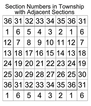
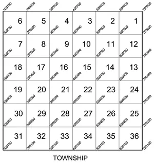
PLSS at a glance
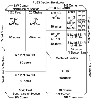
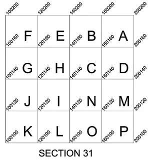
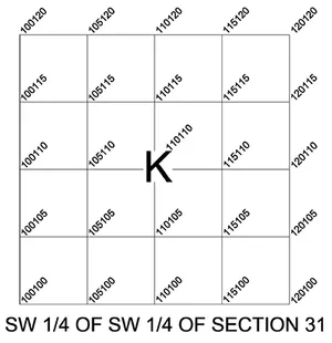
Example Description: A parcel of land situated in the south half of the southeast quarter of the northeast quarter of Section 31, Township 2 South, Range 2 West, Salt Lake Base and Meridian.
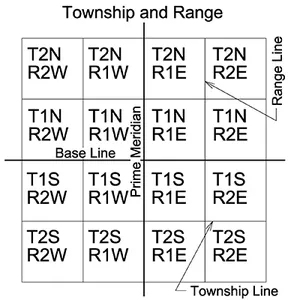
Township and range explained
(5 characters each)
- 3 digits for Township or Range number
- 1 digit for fraction (0 for no fraction, 1 for 1/4 township, 2 for 1/2 township, 3 for 3/4 township)
- 1 letter for direction
Geographic Coordinate Data Base (GCDB) is explained
Bureau of Land
Management (BLM)
Point IDs
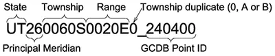
GCDB Point ID
This 6 digit number is the combination of two three letter sequences - XxxYyy.
- The first 3 digits (Xxx)
-
Xxx - may be the same for all points in a similar survey.
- 711 - 719 Town Sites, City Boundaries
- 720 - 739 County Boundaries
- 740 - 769 State Boundaries
- 770 - 799 Forest Service, Parks Service, Reservations,
- Grant, Other Boundaries with Mileposts.
- 800 - 836 Meanders (right bank even #, left bank odd #.)
- 837 - 879 Tracts
- 880 - 899 Right of Ways
- 900 - 999 Mineral Surveys, Homestead Entries, etc.
- The last 3 digits (Yyy)
-
Yyy - Numbered sequentially along the survey in increments of 10. The prefix
- Irregularities of Townships for the first index of [X]xx and [Y]yy
-
1, 2, 8 or 9 → offset corners along interior section lines and section subdivision lines where +/- 2 is the recommended naming scheme.
3 or 7 → offset corners along township boundaries, angle points, witness corners, and witness points.
4 or 6 → intersections of rectangular/special surveys and 1/16th corners of elongated sections.
0 → all regular aliquot corners down to 1/16th.
5 → all regular aliquot corners down to 1/256th.
Common conversions
Distance Conversions
- 1 Mile
-
- → 80 chains
- → 320 rods
- → 320 perches
- → 320 poles
- → 5,280 feet
- → 8,000 links
- → 1,609.2655 meters
- 1 Chain
-
- → 4 rods
- → 4 perches
- → 4 poles
- → 66 feet
- → 100 links
- → 20.1168 meters
- 1 inch
-
- → 0.0254 meters
- 1 Link
-
- → 0.66 feet
- → 7.92 inches
- → 0.2017 meters
- 1 Meter
-
- → 39.370 inches
- → 3.281 feet
- 1 Rod
-
- → 16.5 feet
- 1 Perch
-
- → 25 links
- 1 Pole
-
- → 5.0292 meters
- 1 Foot
-
- → 0.3048 meters
Area Conversions
- 1 Sq. Mile
-
- → Nominal Section
- → 640 acres
- → 2.590 sq. km.
- → 259 hectares
- 1 Acre
-
- → 10 sq. chains
- → 160 sq. rods
- → 160 perches
- → 160 poles
- → 43,560 sq. feet
- → 0.4047 hectare
- → 4,047 sq. meters
- 1 Hectare
-
- → 2.47 acres
- 1 Sq. Meter
-
- → 10.764 sq. ft.