Utah UDOT Routes ALRS
Last update · Weekly
Category: Transportation Data Type: Line GIS data Steward: Utah Department of Transportation (UDOT)
The UDOT Routes ALRS layer is a polylineM dataset wherein each state and federal route is a single feature whose vertices include a milepoint measure coordinate.
Use the data
Explore and Download
UDOT Routes ALRS , opens in a new tab in the SGID on ArcGIS UDOT Routes ALRS feature service , opens in a new tabQuick clips
Feature service URL
https://services.arcgis.com/pA2nEVnB6tquxgOW/arcgis/rest/services/UDOT_Routes_ALRS/FeatureServer/0 Getting started
Learn more about the SGID on ArcGIS.
Tip
You can copy and paste the feature service URL above into ArcGIS Pro or a web map to visualize this data or access
the query endpoint to query the data with your favorite programming language.
A closer look
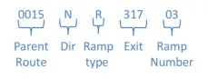
Major routes (shown in the ROUTE_ID field) are named using UDOT’s naming convention (ex. 0089PM is US-89, a mainline route in the positive direction). Ramps and collectors are also included and have 11 character identifiers (ex. 0015NR31703 is at exit 317 on I-15).
Fields worth noting
- ROUTE_ID
-
- P represents Positive direction (increasing milepoint values)
- N represents Negative direction (for divided routes only)
- M represents Mainline
- R represents Ramp
- C represents Collector
- X represents Other
- CARTO_CODE
-
- 1 - Interstate highways
- 2 - US highways
- 3 - State highways
- 5 - Miscellaneous routes associated with interchanges
- 6 - Ramps, Interstates
- 7 - Ramps, US Highways
- 8 - Ramps, State highways
- 9 - Local routes, federal aid
- I - Institutional roads designated as state highways
Please reach out to Ashley Warthen from UDOT at awarthen@utah.gov with questions about this data layer.