Quick Links
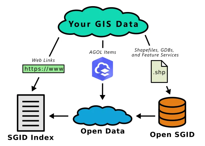
Sharing with the SGID can be a great way to make your data more accessible to the public. All of our sharing methods start with an issue , opens in a new tab in our Porter , opens in a new tab repository on GitHub. This allows everyone a chance to follow along with a dataset's progress in the submission process and to keep an open and transparent record of everything that happened. We also run some checks with Sweeper , opens in a new tab and check that the metadata meets our minimum standards.
We've compiled a page of highlighted datasets showing the importance of collaboration to hopefully give you the nudge to share with the SGID.
The SGID Index
The simplest way to share your data is by adding links for existing, qualifying data (what we call "external data") to the SGID Index, which aims to be a database of all statewide GIS resources. If you are hosting GIS resources on your own server, we can link to your datasets in the SGID Index.
Sharing with the SGID Index
First submit an issue , opens in a new tab in Porter
using the Add external data links to the SGID Index template. Fill out the Summary information
and check the relevant box in the Submitter's Process section.
We will review your submission against the qualifications and reach out with any questions. You can track this in
the UGRC's Process section of the issue.
Once we've worked together to resolve any questions or problems, we'll add your dataset to the SGID Index and close the issue.
UGRC ArcGIS Online
We use Esri's Hub product to offer the SGID on ArcGIS. A centralized list of ArcGIS Online and ArcGIS Enterprise Portal services are available through opendata.gis.utah.gov. This is a great way to use your existing ArcGIS Online or Enterprise infrastructure to share your data with little additional work. We are happy to include any datasets in the SGID on ArcGIS site that meet our qualifications. Just like the SGID Index, AGOL items hosted in your organization are considered "external data."
Sharing with the SGID on ArcGIS
ArcGIS Online items are added to the SGID on ArcGIS by sharing them with one of our SGID groups in ArcGIS Online. This process gives both you and UGRC a chance to review the quality of the item before it is shared. We reserve the right to remove items from SGID on ArcGIS if they don't go through this process.
SGID on ArcGIS relies on information from the source ArcGIS Online item:
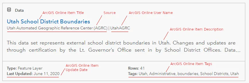
As noted in the qualifications, make sure the following items are taken care of:
- The ArcGIS Online item is publicly shared
- The item has a good title, description, and tags
-
The
Allow others to export data to different formatsin theSettingstab is enabled (if possible) - The
sourcevalue should be set using the method described below
ArcGIS Hub displays the source value on each item and uses it to sort search results. It's very important
for every organization to have a single, unified source. Esri explains where this value comes from in this FAQ , opens in a new tab . To summarize, it first searches the ArcGIS Online item's metadata for an organization name. If it doesn't find
anything there, it falls back to your ArcGIS organization name.
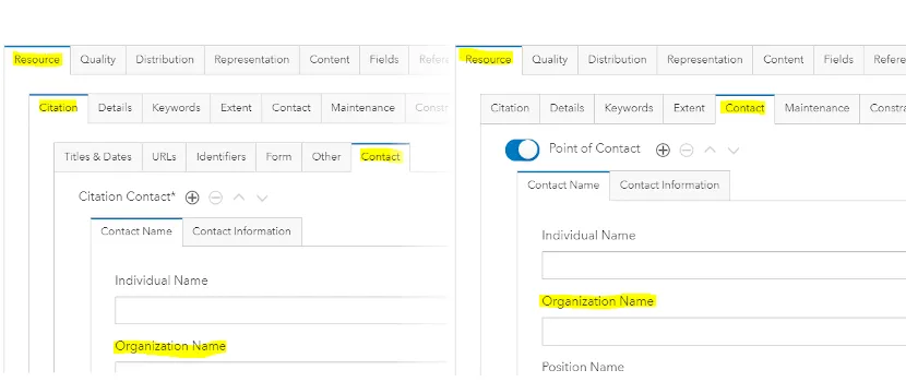
If you want to customize the name displayed, we suggest setting it in the Resource > Citation > Contact > Organization Name metadata field. Otherwise, leave the metadata contact fields empty and it will use your ArcGIS Online organization
name. We use this second way to show Utah Automated Geographic Reference Center (AGRC) as the source for
all our datasets. You may need to remove any values in the metadata contact fields if you want to use your default
organization name.
To edit the organization name in the ArcGIS Online item's metadata, you need to make sure your ArcGIS Online organization has metadata enabled , opens in a new tab . Then you can use the Metadata editor on the ArcGIS Online item page to set either field.
There are a couple of things to check before and after you upload or overwrite your ArcGIS Online items. A common disruptive issue has to do with feature service index ids changing. If you overwrite a feature service, the index id can change if the data is in a different position in the map table of contents at publish time. This creates a new URL to the service breaking all maps and apps that use the feature service. We suggest having a publishing ArcGIS Pro project that only contains the publishing layer with it's index set to 0 (which is the default).
The way you upload or overwrite your ArcGIS Online data may also overwrite the item's metadata with info from the
local source's metadata. We suggest you make any changes in both the feature class and ArcGIS Online metadata to
avoid problems in the future. In the FGDC CSDGM metadata style, the Resource > Citation > Contact > Organization Name field is in Overview > Citation Contacts. The Resource > Contact > Organization Name field is in Resource > Points of Contact.
The Open SGID database
The Open SGID is a curated, publicly-accessible database of statewide GIS layers—the latest evolution of the traditional "SGID as a single geospatial database" model. We are excited to offer a direct connection to everyone once again.
If you have a statewide dataset but don't have the ability to host or share it yourself, we may host it in the Open SGID if it meets our qualifications. We also share most Open SGID layers through opendata.gis.utah.gov (by first uploading it as a feature service in our ArcGIS Online organization). Unsurprisingly, we refer to these datasets as "hosted data."
Maintaining data in the Open SGID requires the most work, both on the front end and for long-term maintenance. We encourage you to share your data via SGID on ArcGIS or the SGID Index whenever possible. However, in order to maintain consistency and familiarity with previous versions of the SGID geodatabase, we may include some datasets in the Open SGID that are otherwise better suited for SGID on ArcGIS or the SGID Index. This is done at our discretion according to our policies.
Sharing with the Open SGID
If you would like to share data with the Open SGID, we will work with you to create a pipeline to identify when and how we'll access and receive updates to the data. We'll run data checks and reviews with Sweeper , opens in a new tab on the data to ensure high quality and share that feedback with you. Fixing the issues in the source will help streamline any future data updates, but isn't necessary to submit the data for the Open SGID. We'll still happily add it to the Open SGID after fixing any issues on our local copy with Sweeper.
Before submitting your data, make sure it has a stable schema and is ready for public consumption. Any future schema changes could be a breaking change that would disrupt users of the data. Make sure the metadata meets our minimum standards. If you need help with metadata, check out our basic metadata creation process.
Start thinking about the future—how often will this dataset be updated? How can we automate the updates? Sometimes, old data is worse than no data at all. If a user can't find anything, they still know what they don't know. But if they find outdated data without realizing it, they may not know that they are acting on outdated information.
Once you've have a chance to think about the above concerns, submit an issue , opens in a new tab in Porter using the Add data to Open SGID template. Fill out the Summary information and
check the relevant boxes in the Submitter's Process section.
We will review your submission against the qualifications and reach out with any questions. You can track this in
the UGRC's Process section of the issue.
Once we've worked together to resolve any questions or problems, we'll add it to the Open SGID.