Utah Terrain Base Map
Last update · May 2026
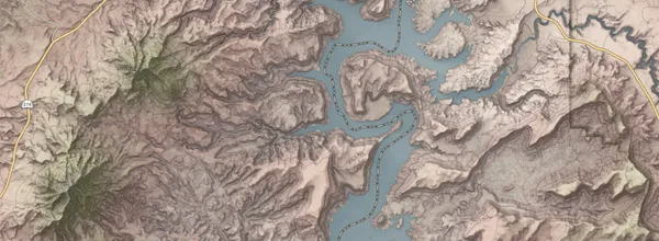
The Terrain base map highlights natural land forms and vegetation. It uses land cover polygons in conjunction with a digital elevation model (DEM) to display the different regions, elevation, and physiography of the state. A unique 2 layer hillshade and 50 foot contours highlight landforms and the shadows they cast. Other unique layers include water related land use agricultural areas and 2016 Great Salt Lake level.
Use the base map
From Discover
A closer look
This base map contains contours, agricultural lands, and wetlands, as well as man made features like highways, rail, parks and some local, state, and federal boundaries. Local features like building footprints and address point house numbers display as you zoom in.
These raster tiles are pre-rendered at the common zoom scales , opens in a new tab . with a Web Mercator WGS84 projection (wkid/EPSG 3857).
Update history
- May 2026