From the blog
Currently displaying: Developer
Desktop Shorts: Streaming Down the GDAL Pipeline (4 min)
In May of 2025, GDAL (the Geospatial Data Abstraction Library) released version 3.11 of their ubiquitous raster (and vector) processing library and related tools.As part of their focus on the CLI expe
Python Shorts: Point Me to the Nearest Points with GeoPandas (5 min)
One analysis that comes up regularly in GIS is figuring out the relationship between two different sets of data. For example, let's say we've got an address point layer (symbolized with circles) and a
Unlock secure automated code signing with Google Cloud KMS (10 min)
In the world of software engineering, nothing stays the same for very long. What was considered a best practice and secure a few days ago can quickly become a code smell and a liability in today's thr
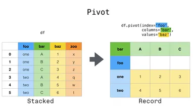
Python Shorts: Pivoting in Pandas (10 min)
When we analyze a GIS layer, we often want to use one of the attributes to group the features and see how other attributes differ amongst the groups. For many GISers, it's second nature to do this vis
The Geocoding Toolbox is being deprecated (2 min)
First, the historyBack in 2014, we released a custom python toolbox for ArcGIS Desktop called the Geocoding Toolbox. It allowed users to geocode Utah addresses using the UGRC API. It was a great tool
SGID breaking changes from SITLA (3 min)
If you depend on any of the geospatial services from The School and Institutional Trust Lands Administration (SITLA), you might have noticed that the services started having issues on the 5th of Octob
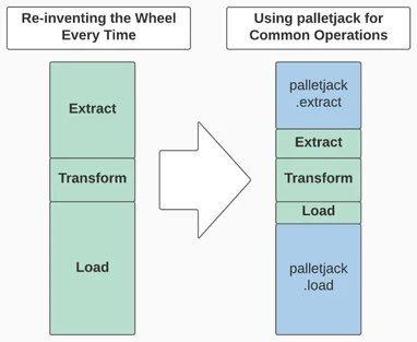
Introducing palletjack: Updating AGOL feature services from external sources (6 min)
Do you hate writing the same bits of code over and over again? Do you hate fixing the same thing again and again? Do you think "there's got to be a way to do that, but I don't have time to figure it o
Python Shorts: Loading an Open SGID Layer into pandas (3 min)
There are a myriad of ways you can access data from the Open SGID. However, these all require some form of desktop client application. What if you want programmatic access to our spatial data? Because
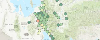
Aggregating and Analyzing Point Data with H3 Hexes and Pandas (10 min)
I recently discovered Uber's open-source H3 geospatial indexing system while working on a project with a lot of point data. This is a great tool for aggregating points into regularly-sized polygon geo
Python Shorts: The Benefits of Unit Testing (6 min)
In the realm of programming, "unit testing" is an automated way of testing small, individual "units" of your code to ensure that when given a specific set of inputs they return a specific set of outpu
Python Shorts: Flattening Arrow Code (5 min)
"Arrow Code" refers to a series of nested statements that increase your indentation level at each statement, creating an arrow of whitespace when the s are mirrored by accompanying blocks.While arro
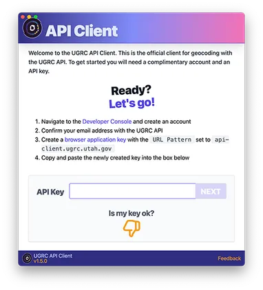
Introducing the Official UGRC API Client (2 min)
Assigning a geographic coordinate to an address, otherwise known as geocoding, is one of the simplest ways to enable data to be visualized on a map. This makes geocoding a gateway to a Geographic Info
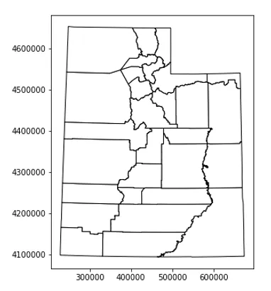
A Brief Tutorial on Exploring the Open SGID with Open Source Python Tools (7 min)
The accompanying Python Notebook for this blog post can be found here on Google Colab.The Open SGIDThe introduction of the Open SGID has opened the door for new ways to explore Utah's GIS data. Before
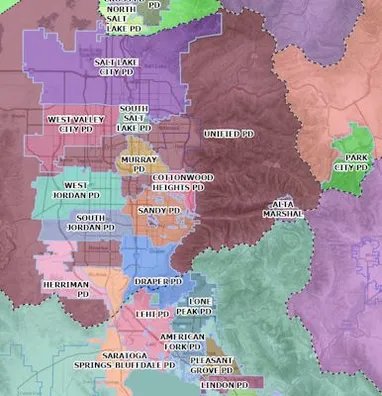
Automating Next-Generation 911 Law Enforcement Boundaries (3 min)
UGRC has created a Python script for law enforcement boundaries that automatically builds jurisdiction polygons based on existing boundaries (primarily county and municipal boundaries) in the State Ge
Using Jupyter Notebook for UGRC Collaboration (4 min)
At UGRC we greatly value collaboration and sharing ideas. A terrific technology to support these values is the Jupyter Notebook project.Jupyter Notebook consists of a web application tied to an interp
Thoughts from Teaching Google and Amazon New Skills (9 min)
Developing software for digital assistants is fun and a refreshing change from typical GIS projects. Over the past few months, UGRC was lucky enough to spend some time developing equivalent skills for
Leveraging Git and GitHub to Manage the Lifecycle of Custom ArcGIS Tools (13 min)
As GIS developers, we are often expected to provide the same custom tool for multiple versions of ArcGIS Desktop (or ArcGIS Pro). For example, some users are on Desktop 10.4, while others are on 10.6
Don't Make Users Think about Updating Software (6 min)
As software developers, we want the people who are using our software to ~~enjoy~~ the experience. Developers strive to create a positive user experience to increase the popularity and usage of their
Cache-Breaking for Faster Web Application Updates (4 min)
When Production Is Broken, It Needs to Be Fixed Now!Recently, the URL changed for one of the map services we use in several of our applications. This came as a bit of a surprise to us, so we quickly u
Dumbing Down Terrain with Contour Polygons (4 min)
While technology advances towards products with greater resolution and accuracy, sometimes more data isn’t always better data. Sometimes, being able to see general trends and relative differences pain
The Evolution of a Python Script (7 min)
Python is a very approachable programming language and scripting in python is quick and powerful - Create a file, type some code, and a repeatable script is produced. Python is installed on most compu
UGRC System Status Page (2 min)
Over the years, GIS is trending more and more towards being web-based. UGRC has tried to keep step with this trend with the addition of the discover, the Turn GPS RTK GPS service, and the Web API hand
Rethinking Geocoders: Adding Local Vernacular into the Build Process (5 min)
UGRC has been working on a project to enhance our approach to geocoding. This grew from the basic idea that humans often view addressing differently than a GIS system. For instance, as GIS professiona
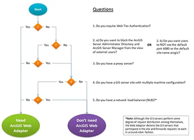
Removing and Replacing the Esri Web Adaptor (3 min)
The Esri web adaptor is a small load balancer/reverse proxy bundled into the ArcGIS Server install but do you know if you need it?ArcGIS Server runs an http server exposed over the private port 6080.
Printing Web Maps with Discover Services (3 min)
Export Web Map ToolThe Export Web Map tool is a geoprocessing tool that comes published as a service () out of the box with ArcGIS Server. From ESRI's docs:This is most commonly used as a print servic
Forced GitHub; A reflection on a new website using GitHub and Jekyll (7 min)
The first commit to our version 6 website was one year and eight months ago on May 26, 2015. We went live with the v6.0 on March 25, . Between that first commit and launch, we started an internal camp
Why I Speak at Conferences and You Should Too (2 min)
Recently, I tried to gather all of the presentations that I have participated in during my career up to this point (~10 years). I was able to find materials for almost 20 different presentations or wo
Mock your Dojo AMD modules with StubModule.js (2 min)
When testing AMD modules it is sometimes necessary to verify how it interacts with it's dependencies. For example, you might be writing a module that makes XHR requests using dojo/request and you want
Boost Your Productivity With Vim (3 min)
I was surprised to realize today that I have never written about one of my favorite tools that I use to write code. It's something that absolutely transformed my day-to-day coding. If it was suddenly taken away from me I would feel like I had gone back to the dark ages. That's right, I'm talk about Vim. Or more specifically Vim key bindings. Vim (Vi IMproved) [https://en.wikipedia.org/wiki/Vim_(text_editor)] is an old text editor that was first released in the 90's and is an improvement to an even older editor called Vi. The intriguing part of Vim for me was not the 20 year old piece of software but the system that it used to edit and navigate text. It's very efficient, requiring the coder to reach for his or her mouse almost never. Lest you think that I've abandoned my favorite text editor [https://atom.io/], the real power of Vim for me is not the actual software. In fact, I've only opened it up a few times out of curiosity. The power of Vim is the standard that it's set. There are Vim emulator plugins for every major text editor out there including Sublime [https://github.com/guillermooo/Vintageous], Atom [https://github.com/atom/vim-mode] and even online editors such as CodePen [https://blog.codepen.io/2014/02/21/vim-key-bindings/]. This means that if you invest the time into learning Vim commands they will be almost universally applicable across your development tools. Want to quickly go to the end or beginning of the current line? Change everything within the quotes? Delete everything from your cursor to the end of the line? Quickly go to a line number? Change the casing of the selected text? This and much, much, much [https://www.catswhocode.com/blog/130-essential-vim-commands] more can be done with just a few Vim commands. Here are a few of the commands that convinced me that I should learn Vim: * "A" Go to the end of the line and start inserting new text. * "I" Same as "A" but go to the start of the line * "ci"" Delete everything within the quotes and start inserting new text * "C" Delete everything from the cursor to the end of the line and start inserting * "545 gg" Go to line number 545 * "ct," Delete everything until the "," and start inserting new text These are just a few of the commands that I use every day. While it's significant learning curve, the time investment is worth it to me. After all... > Every year, the average Vim user saves over 4 seconds in accumulated time not > having to reach for their mouse… > > — I Am Devloper (@iamdevloper) April 3, 2014 > [https://x.com/iamdevloper/status/451792390865833984] There are endless tutorials available for you to learn Vim. After learning just a few of the basics I made it my practice to add one or two new commands to my personal reference [https://www.evernote.com/l/ABdguLm6UtRExY8VU_EZWbfJvRKE6rpjTCM] on a regular basis. After a few weeks you'll wonder how you ever lived without it. There are a few drawbacks that come to mind. Firstly, after a few months of using Vim, your fingers will start automatically typing commands into non-Vim interfaces. This can get annoying. Also, you've probably already realized that the learning curve is pretty steep. If you are not in a code editor on a daily basis then it's probably not worth the investment. But if you're in the mood to boost your productivity and give your poor mouse a break you may want to play some vim golf [https://www.vimgolf.com/] and see how it goes. :)
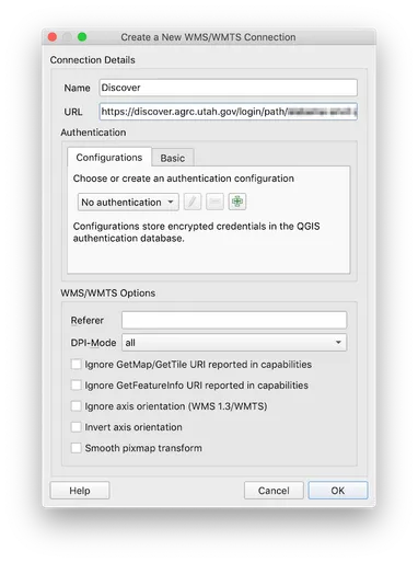
How To Use UGRC Base Maps in QGIS (1 min)
Most people know about UGRC's awesome base maps. They are very popular and provide high quality cartography using the latest and greatest data from the Utah SGID. But did you know that they provide a